Stories in the Rocks
The structure of sediments is determined by forces in the Earth’s interior and external environmental factors alike. It tells us about earth history and large-scale geological processes and allows the geologists at the University of Vienna to determine the risk of strong earthquakes and examine the human impact on the earth system.
Feb. 1, 2016
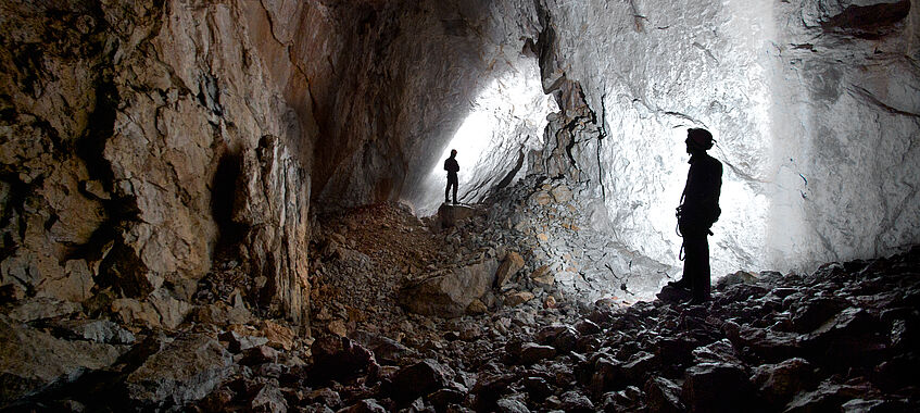
Rocks as long-term archives preserved in caves: They allow the geologists to look back to the past and understand former earth surface processes, climatic changes and tectonic activities.
Copyright: T. Exel
Geological forces keep the Alps in motion. Studies show that the Eastern Alps are shifting to the east at a rate of 1.5 mm a year. That does not happen without seismological shocks. Of the approximately 100 annual earthquakes in Austria, only just over a dozen of them are felt by the population. It is not clear whether “strong” earthquakes – quakes with a magnitude of over six on the Richter scale – are possible in the Eastern Alps. Strong earthquakes might also only occur at intervals of a thousand or several thousand years – the existing seismological records do not reach back far enough to tell. In order to collect data on strong earthquakes, the Research Group Structural Processes uses a very special archive of earth history.
Caves as archives
The researchers look for signs of movement in caves: There, often several hundred metres below the surface, scratches in and displacements of the calcareous sinter speak of past quakes. “In the Alps, it is hard to find proof of active tectonics, that’s tectonic movement in the last 10,000 years. The last ice age eroded the Alps so heavily that all traces have been obliterated. In caves, however, these signs remain visible,” says Bernhard Grasemann, Head of the Group.
The reputation of structural geology in Vienna is, among other factors, based on combining geological field data with the numerical modelling of deformation processes.”
Bernhard Grasemann, Professor of Geodynamics and General Geology
In cooperation with the Natural History Museum Vienna, geologists are collecting signs of earthquakes from the last 500,000 years in several different caves. They compare their data from the Eastern Alps with data from sinter caves in the southern Aegean, a tectonically very active region. The results do not only serve to complement historical records: “If we know the rate at which earthquakes repeat, we can evaluate probabilities more precisely,” says the Head of the Department of Geodynamics and Sedimentology. The FWF project “Speleotect” is the first comprehensive study on Quaternary tectonics in the Eastern Alps.
In a different project, geologist Kurt Decker studies active tectonics in the Vienna Basin. In 2015, he was able to demonstrate that there are fault lines and fault systems underneath the Vienna Basin that are serious enough to cause a strong earthquake. At the same time, the structural analyses of the Vienna Basin and other tectonically active regions also provide data that are useful for petroleum geology. Active and inactive faults have a considerable influence on where reservoirs of fluids, such as hydrocarbons (e.g. petroleum), can form in the Earth’s crust. The Department cooperates with the oil industry in basic research projects.
Rock deformation processes
The analysis of the behaviour of deformed rocks when subjected to natural faults is one of the key research areas of the Research Group Structural Processes. A current doctoral thesis focuses on ductile or plastic deformations of rock. Under surface conditions, glacier ice behaves similarly to ductile rock at a depth of approximately 20 km and temperatures of 400 to 500°C (e.g. marble). The way the ice flows can tell us how rocks behave deep down under the earth where they cannot be observed directly. Therefore, the researchers around Grasemann and his colleague Martin Schöpfer want to use Austria’s largest glacier, Pasterze on Großglockner, as an analogous laboratory to model the flow and deformation behaviour of the ice.
Another project, which starts in 2016, will be dedicated to the numerical modelling of calderas – craters of volcanoes whose magma chamber has collapsed. The project, which received the Department’s Emerging Field Grant 2015, will study how calderas collapse. The objective is to develop state-of-the-art 3-D computer simulations of restless calderas to gain insight into volcanic processes. This will contribute to understanding the potential dangers of the craters. The researchers are collecting data from calderas on the Canary Islands.
Small traces, large impact
How are sediment rocks structured? Which depositional processes can we deduce from the order of the sedimentary layers? How do sedimentation dynamics and environmental conditions influence them? These are questions that the Research Group Sedimentology and Stratigraphy are studying in several projects. Among other things, they are investigating the potential of rocks to store petroleum, studying the climate on our planet 10,000 to 100,000 years ago and investigating fluctuations in sea level under palaeoclimatic conditions to allow us to draw conclusions about changes that can be expected during the current climate change.
In addition to these diverse research questions of sedimentology, there is also a heated debate among geologists concerning a fundamental question: When did or will the influence of humans on the environment become so strong that we influence geological processes in the earth system? Has the so-called Anthropocene already started? And if so, when? “These questions focus on humankind and our environmental, geological and atmospheric footprint,” geologist Michael Wagreich explains.
Has the Anthropocene started?
The term “Anthropocene” was coined in 2000 by the Nobel Prize laureate in Chemistry, Paul Crutzen. Researchers do not agree whether it has already started or not. Michael Wagreich is a member of a working group of the Subcommission on Quaternary Stratigraphy of the International Commission on Stratigraphy (ICS) together with Paul Crutzen and others. The ICS is in charge of naming geological epochs and is currently considering whether the Anthropocene epoch should be formalised and when its beginning would be.
Everyone is talking about the Anthropocene. There is much evidence of human influence. Now, this new geological epoch should be formally defined.”
Michael Wagreich, Deputy Head of Department
In a 2015 publication, the researchers found that in terms of stratigraphy, it would be ideal to place the beginning of the Anthropocene in 1945. The explosion of the nuclear bombs and the nuclear weapons tests in the following years caused artificial radioactive isotopes to enter the atmosphere, which have since then spread worldwide. “The plutonium isotopes that can be detected in ice cores from the Antarctic are the same as in lakes in Europe or ice cores from Greenland,” says Wagreich. In January 2016, Wagreich and international colleagues published an article in the renowned journal Science reflecting on issues that can be considered as evidence of an Anthropocene epoch. However, critics point out that the radioactive material is still being spread and depleted and say that a geological epoch cannot be defined based on active processes.
Wagreich and his team want to examine other markers for the beginning of the Anthropocene. This epoch would follow the Holocene, which began 11,700 years ago. The considerable spread of aerosols and deposits of lead particles in the Northern Hemisphere are, for example, connected to the intense mining activities of the late Bronze Age. “Isotope analysis of sediments shows lead from that time period in stratigraphic terms,” says Wagreich, who analyses sediments in rivers and lakes, in particular. “We are particularly interested in the history of how these first contaminants caused by humankind spread.” The geologist expects to be able to find lead particles in the sediments from approximately 3,000 years ago in Austria as well. However, stratigraphy is also interested in more recent phenomena: Traces of human behaviour, e.g. the use of plastics, can also be found as microscopic plastic particles in younger sedimentary layers, which is being referred to as “plastic stratigraphy”.