Planet Earth
Whether we are talking about mass movements of sediments or the circulation of greenhouse gases, migration across borders or regional migration processes – our world is always in motion. The geographers at the University of Vienna study the world in its multiple aspects.
Feb. 1, 2016
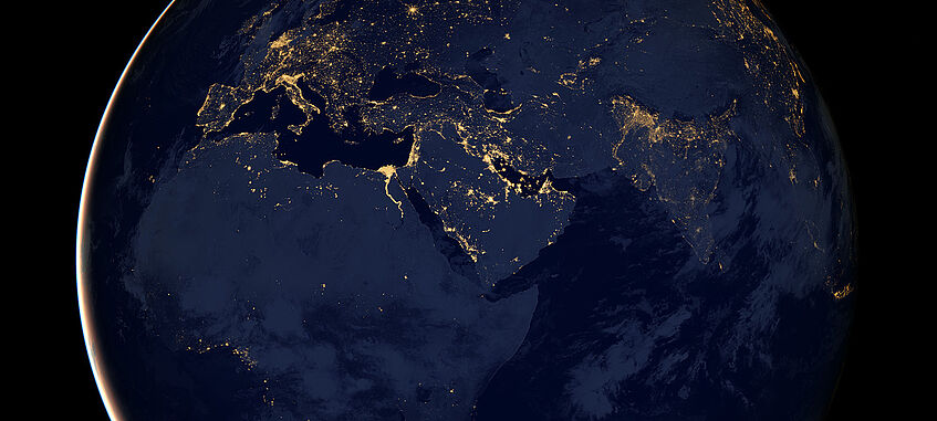
A nighttime view of planet Earth. This image of Europe, Africa, and the Middle East is a composite assembled from data acquired by the Suomi NPP satellite in April and October 2012.
Copyright: NASA Earth Observatory image by Robert Simmon, using Suomi NPP VIIRS data provided courtesy of Chris Elvidge (NOAA National Geophysical Data Center). Caption by Mike Carlowicz.
Avalanches, earthquakes and landslides can generate tremendous force, which may result in disastrous consequences for humans and the environment. While avalanches and earthquakes have been studied in detail for decades, “there are very few continuous monitoring programmes for landslides such as shallow or rotational slides, mudflows or rockfalls,” says Thomas Glade, Head of the Research Group Geomorphological Systems and Risk Research. The key research areas of the Group are earth surface processes, natural hazards and risk assessment.
With their project NoeSLIDE, which was launched in 2014, the geomorphologists are, for example, addressing the lack of long-term studies on landslides. They have established an early warning system for landslides, mudflows and rockfalls in different parts of Lower Austria. The combined use of sensors and laser scanners allows Glade’s team to analyse the different flow, fall and slide processes. They also record external factors such as precipitation, solar radiation and temperature. At the same time, they aim to develop fundamental knowledge concerning the following questions: How can the risk associated with landslides and similar events be minimised? What can be done to prevent them? What should be done to handle an emergency situation, including risk communication? With their project BioSLIDE, the researchers investigate whether changes in vegetation or biomass influence the motion dynamics of slopes.
Environmental processes, environmental hazards
The Research Group Geoecology, which is the Department’s second group that studies geography from the perspective of natural sciences, also focuses on current environmental processes and problems. One example are greenhouse gases.
How do the exchange processes of greenhouse gases occurring between the soil, plants and the atmosphere look like? How does human influence change them? Stephan Glatzel’s Geoecology Group addresses these question on the basis of peatlands – a rather young research area at the Vienna Geography Department. Peatlands are carbon sinks, provided that they remain undisturbed. When peatlands are used or drained, harmful greenhouse gases, such as carbon dioxide, are released.
Stephan Glatzel estimates that up to 3 % of Austria’s surface could be considered peatlands, following the international definition (i.e. areas covered by a peat layer of at least 30 cm). However, there is no comprehensive survey on peatlands, and the data are too old to be used as accurate information. The only peatlands that have been exactly charted are found in nature reserves. Additionally, peatlands have not been taken into account as far as Austria´s climate footprint is concerned. “We do not know how it would influence the balance if we included them,” says Glatzel. The researchers are investigating the changing impact that peatlands have on the climate, e.g. on the basis of the “Pürgschachen Moor” located in Styria. They have already found that the severe drought in the summer of 2015 promoted the spread of dwarf pines in the peatlands.
Geography of humankind
Whether through construction work, agricultural use or by causing greenhouse gas emissions – the anthropogenic influence on ecosystems and the interaction between nature and society play an important role in physical geography. The second large area of geography in Vienna focuses on the people themselves: Human geography deals with different aspects of demographic change, rural depopulation and with the increasing migration into cities or urban spaces as well as with spatial planning matters.
Life expectancy in Austria is increasing at an average rate of two years per decade. In the following years, there will be a considerable increase in the number of elderly people in comparison with other age groups. We need concepts for integrating elderly people into society as long as possible – for example through employment or volunteer work. Currently, two dissertation projects carried out within Heinz Fassmann’s Research Group Applied Geography focus on active ageing. Over the last ten years, the rural peripheral regions of Austria, which are characterised by young people migrating into the cities, have seen an influx of people moving into these rural areas at the end of their working life. This is, for example, true for the southern Burgenland. The question arises whether these elderly people are indeed “new immigrants” and why they move there or where they actually come from. The researchers also want to study the potential that these new residents have for the development of municipalities.
“Demographic change and the depopulation of structurally weak areas are associated with a strong gender bias,” says Robert Musil, Head of the Research Group Human Geography. “More women than men leave the rural areas for cities.” Researchers from his Group have studied the impact of the gender aspect on regional development: The project genderATlas (genderatlas.at), for example, shows which municipalities in Austria have female mayors (the first female mayor was sworn in in Lower Austria in 1948) and examines in which Austrian regions young women and men have a particularly high level of education. The interactive online map was presented in the autumn of 2015.
Country life and city life
Further topics studied by the human geographers at the University of Vienna include the integration of ethnic minorities in Vienna, the development of inner-city districts in five major European cities, the development of financial centres in Europe and urban agglomerations. Another research topic comprises spatial planning methods and systems: A team working in the Research Group Applied Geography led by Hans-Heinrich Blotevogel compared the different spatial planning systems of European countries. The researchers were interested in examining how these countries deal with current challenges such as climate or demographic change and whether and how quickly institutions reacted to them.
Geography is characterised by natural and social sciences. When it comes to solving problems, physical and human geography work hand in hand. This allows us to understand the complicated links and interdependencies that are so important today.”
Hans-Heinrich Blotevogel, Professor of Applied Geography, Spatial Research and Spatial Planning
The Research Group Population, Environment and Development also studies changes in spatial structures, regional development dynamics and demographic changes such as ageing processes and their consequences, focusing in particular on South and South-East Asia. In January 2016, Patrick Sakdapolrak took over as Head of the Group, as Helmut Wohlschlägl retired at the end of 2015. The new Professor of Population Geography and Demography recently analysed climate change, migration and social resilience of rural communities in Thailand. In future, Patrick Sakdapolrak’s Group will focus on population dynamics at the interface of environmental change and social transitions.
Visualisation of geodata
Geography seeks to gain a comprehensive understanding of our physical and social world and all its interactions. Modelling processes and changes are a key tool in this regard. Vienna has a long tradition of research on the visualisation of geographical information. The Research Group Cartography and Geoinformation has gained international reputation with its work on the so-called hyperglobes. Bands of clouds move around the world in real time, continental drift can be seen in time-lapse, hot spots of greenhouse gas emissions become visible – digital technology has given the traditional globe a new face.
Our Department covers the entire range of geography as well as cartography and geo-information sciences. They complement each other in the extensive tasks at the interface of the environment, society and risk.”
Wolfgang Kainz, Professor of Geography and Cartography and Head of Department
By projecting digital geodata onto the globe, “we are able to increase the understanding of many different issues,” say Head of the Research Group Cartography and Geoinformation, Wolfgang Kainz, and his colleague Andreas Riedl. In 2005, the University of Vienna was the first European research institution to present a tactile hyperglobe. Today, the globe’s “library”, developed together with different cooperation partners, includes over 300 geographical topics. At a price of approximately € 100,000 the globes are still too expensive for everyday use, but smaller, more affordable globes, onto which many dynamic phenomena of our planet can be projected, are already being developed.
Teaching Geography and Economics
The Research Group Didactics of Geography and Economics provides theoretical and practical training for the approximately 1,700 students who are studying to become Geography and Economics school teachers. “For us, didactics does not only represent the theoretical basis of successful schooling but also a research area in the field of social sciences,” says Christiane Hintermann, who has been coordinating the Group since the spring of 2015. Researchers in this field discuss subject-related ideas as well as insights from didactics of related disciplines, educational science and practical work at school and adapt these insights so that they can be used for the education of future Geography and Economics teachers. The aim is for students to develop the ability to explain the theoretical basis of their decisions concerning teaching methods and content. While emphasis is currently placed on the key research areas of migration and diversity as well as textbook analysis, future research should increasingly focus on questions of political education, the integration of fundamental concepts of geography (such as place and space) into teaching and the implementation of competence-oriented curricula. The Group is also involved in the publication of the journal GW-Unterricht (www.gw-unterricht.at). It is very important to maintain national and international contacts and to cooperate with various partner schools.